


As the deadline to select a map draws closer, Tulare County moved ahead with four possibilities for new Supervisorial districts earlier this week.
The Tulare County Board of Supervisors assessed four maps and directed county staff to make adjustments to each one to review at a future meeting.
ADVERTISEMENT
The board selects to select a final map on Nov. 9 and officially adopt it on Dec. 7, a week before the deadline.
Tulare County is under no legal obligation to adopt one of the four submitted maps, but lawsuits could be incoming.
Last month, Dolores Huerta Foundation lawyer Maggie Melo told the Tulare County Advisory Committee on Supervisorial Redistricting that the foundation will likely sue the county if the Equity Coalition Map – backed by the foundation and other groups – is not adopted.
However, the Equity Map proved to have its issues with the board. One of which is the formation of a “mega-mountain” district, which is present in three of the proposed maps.
If the board moves ahead with a mega-mountain district, Porterville and the vast majority of Tulare County’s mountain region would be grouped together, a vast change from the current setup that has three supervisors representing portions of the mountain population.
“If we were to reduce to one or two supervisors, if push ever came to shove, you’d actually reduce the amount of influence that the mountain residents would have on this board,” Supervisor Dennis Townsend said. So just a caution as we go through reviewing all of the maps.”
The board agreed with Townsend’s point, leading Board Chair Amy Shuklian to say that mountain constituents would be less-served in one overarching district.
“Just giving the example right now with Supervisor Townsend living in Springville, that’s almost as far south as you can get,” Shuklian said. “So those folks way up there in the northern area, accessibility, roads and what-not – I think they would be served less by having a mega-mountain because their supervisor would not be as accessible to them. So that’s why I would like to see at least a two-district mountain area, but that’s the reason why I really do not favor a mega-mountain.”
All four maps would create three Latino-majority districts.
Here’s a look at the four maps that the county is considering for approval:
Equity Coalition Map
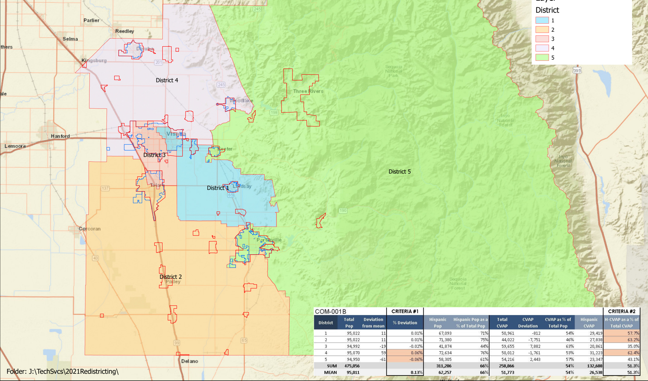
One of the three mega-mountain maps, the Equity Coalition Map would also split Tulare between District 2 and District 3.
That would put parts of Tulare and Visalia together in District 3, a major change from the current setup.
Supervisor Larry Micari noted that the map does not meet all of the criteria detailed from the county by not keeping Tulare whole and by separating Terra Bella and Ducor from Porterville.
“There are other maps that meet all of the criteria that seem to be better suited,” Micari said.
The Hispanic voting age population as a percentage of the total voting age population in the Latino-majority districts is as follows:
- District 1: 57.7 percent
- District 2: 63.2 percent
- District 4: 62.4 percent
The board directed staff to redraw the map with Terra Bella and Ducor grouped in with Porterville, keep Tulare whole, expand the area around Exeter and split the mega-mountain district.
Wells Map
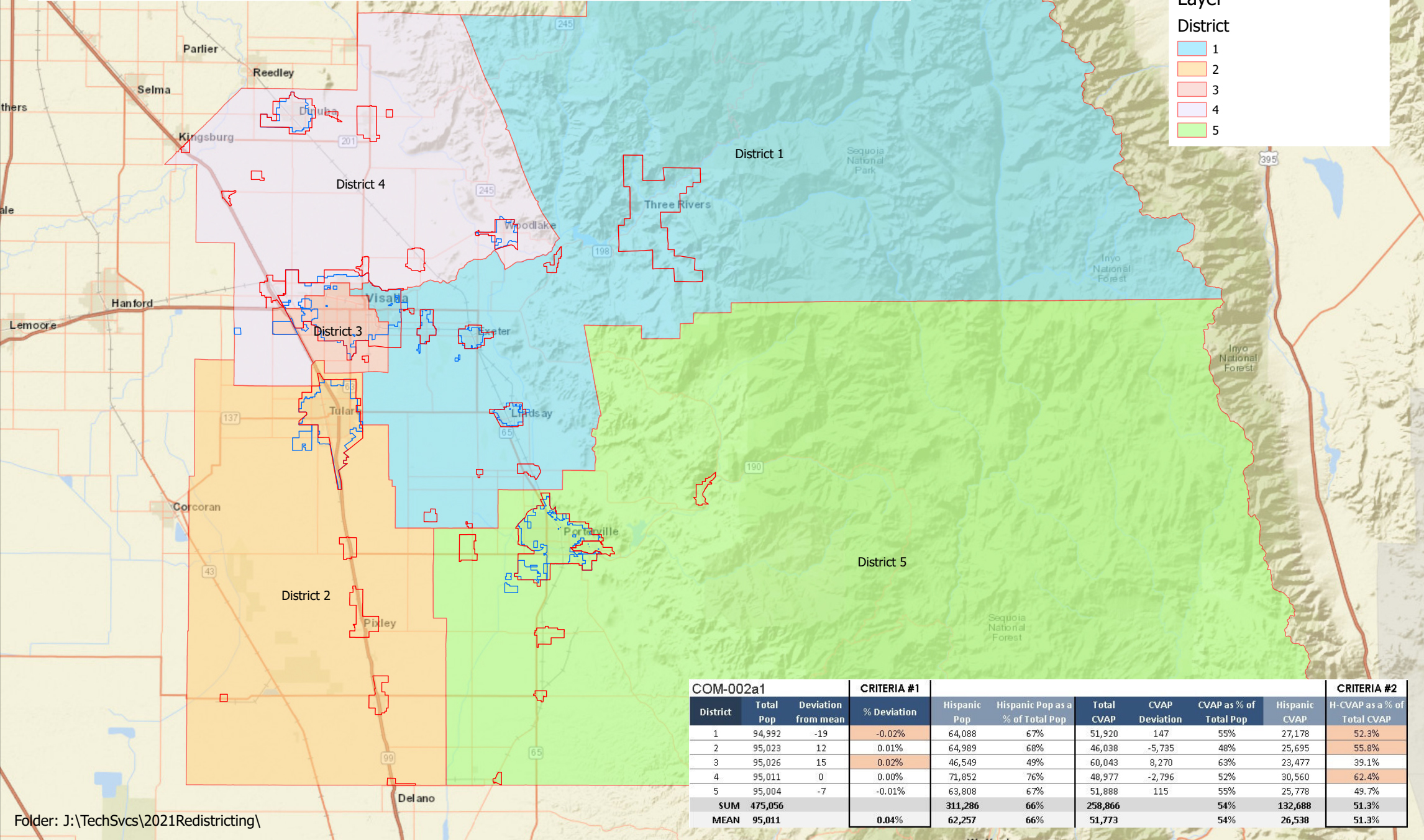
As the only map to not have a mega-mountain district, the Wells Map would see the mountains represented by two supervisors.
Tulare would be kept whole in District 2 for the most part, but some outlying Tulare addresses would be grouped in District 1, District 3 and District 4.
The Hispanic voting age population as a percentage of the total voting age population in the Latino-majority districts is as follows:
- District 1: 52.3 percent
- District 2: 55.8 percent
- District 4: 62.4 percent
If the Wells Map was accepted as is, District 1 would open the door to a lawsuit from the Dolores Huerta Foundation over the need to preserve a because of federal Voting Rights Act requirements for Tulare County needing three districts to have at least 55 percent hispanic voting age population percentage.
The board directed staff to expand the areas around Tulare to include all Tulare addresses in District 2 and to adjust District 3 so it covers the area to its west out to the county line, as it currently does.
Verduzco Map

Mega-mountain is back with the Verduzco Map, but the population numbers would require some fixing before it could be approved.
The map had the highest population percentage deviation out of the four. District 1 would have over 97,500 people, while District 3 was on the low end with just over 93,000 people.
The Hispanic voting age population as a percentage of the total voting age population in the Latino-majority districts is as follows:
- District 1: 58 percent
- District 2: 55.8 percent
- District 4: 63.2 percent
The board asked county staff to expand the borders of District 1 around Exeter and to expand District 2 to include all Tulare addresses and move its northern border up to Avenue 264.
Notably, the supervisors did not ask for the mega-mountain district to be split up for this map.
Kindschuh Map
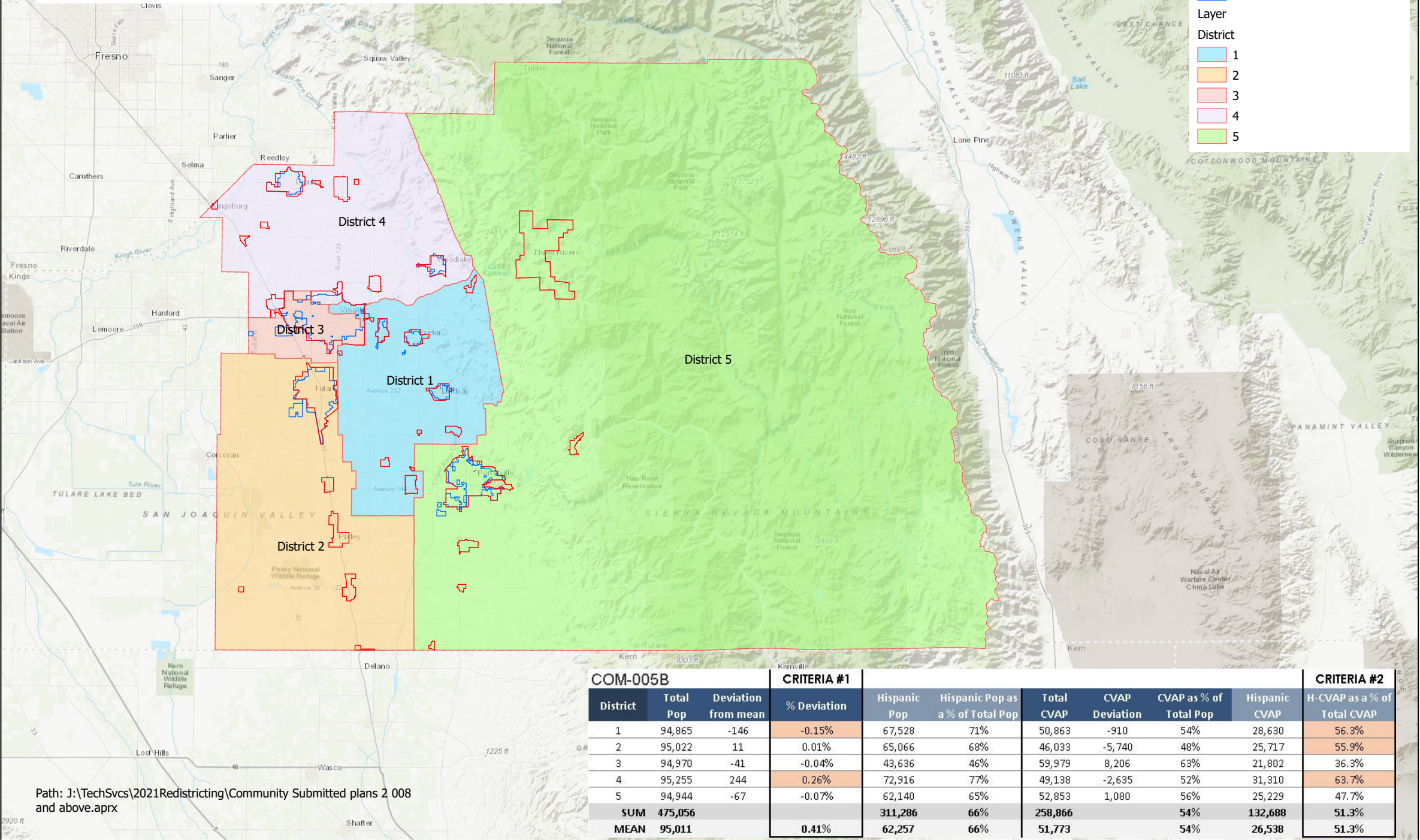
While District 2 would encompass most of Tulare, some Tulare addresses on the eastern and northern edge of the city would be placed in other districts.
Most of Visalia would land in District 3, but parts of the county’s largest city would end up in District 4 and District 1 as well.
The Hispanic voting age population as a percentage of the total voting age population in the Latino-majority districts is as follows:
- District 1: 56.3 percent
- District 2: 55.9 percent
- District 4: 63.7 percent
The supervisors directed county staff to subdivide the mountain district and to expand the boundaries of District 2 around Tulare to include all Tulare addresses.