


The latest wave of sopping rain storms has arrived in the San Joaquin Valley, prompting local communities to strengthen flood preparedness and ready road crews over storm damage.
While cities prep sandbag giveaways for potential flooding along with the opening of storm response centers, local law enforcement is having to focus on road conditions across the Valley floor and in the Sierra foothills.
ADVERTISEMENT
What we’re watching: Storm reaction in Fresno County has been particularly aggressive, with its two largest cities rolling out rapid response plans in coordination with the Fresno Metropolitan Flood Control District. But the biggest hurdle may reside in the foothills.
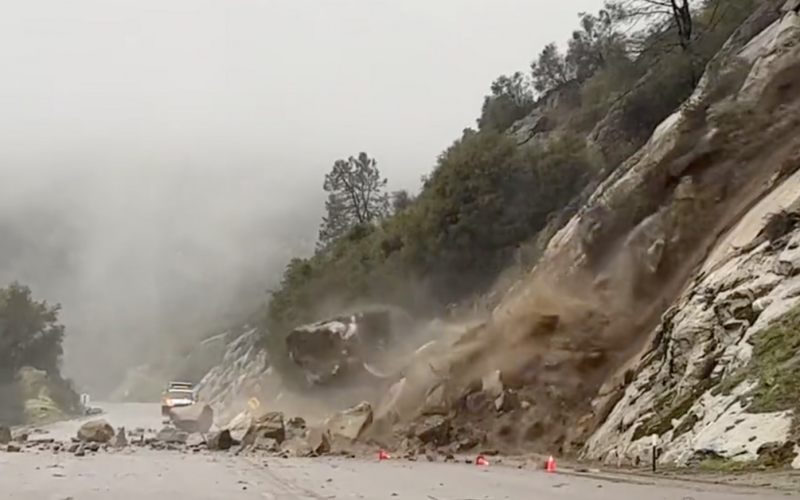
- One day after Highway 168 reopened at the ‘Four Lane’ following repairs to massive potholes, storm-driven rockslides shuttered the road to Shaver Lake. CHP crews took jarring footage from the roadway. from
EXTREME CAUTION
STATE ROUTE 168 CLOSED at top and bottom of 4-lane.
See dramatic video from @ChpFresno Officer.
Avoid travel to Shaver Lake and above if at all possible!⚠️ @ABC30 @KSEE24 @KMPHFOX26 @CBS47 @FresnoBee @FresnoSheriff @CaltransDist6 @Cal_OES pic.twitter.com/0B2Qqgm85z— CHP Fresno (@ChpFresno) January 9, 2023
- Fresno County declared a state of emergency and activated its Clovis-based Emergency Operations Center to manage on-going flood issues as the storm transitions into Tuesday.
- City of Clovis crews have shuttered Ashlan Ave. between Thompson and Highland avenues over “weather-related damage.” Traffic is now being re-routed.
- The City of Fresno activated four 24-hour “storm centers” at Maxie L. Parks Community Center, Mosqueda Community Center, Pinedale Community Center, and Ted C. Wills Community Center, coupled with free bus service to the centers, three meals, and cots and blankets available for residents.
- Fresno County shuttered Lost Lake Park, located just south of Friant Dam, indefinitely due to flooding concerns.
The big picture: Meteorologists warned over the weekend that a battering of rain storms in central California were on their way. However, they note that the current waves of year-end, year-start storms are different from the handoff between 2021 and 2022, where late December/early January dousings marked the beginning and end of storms for much of drought stricken California.
What they’re saying: “Factoring in the storms that began in late December forward through mid-January, rainfall and mountain snow in some areas could rival amounts that do not occur, on average, for 25 or 50 years or more,” AccuWeather senior meteorologist Mike Doll said.
- “Storms are likely to resume during February and March, just probably not to the magnitude as is occurring now and what is likely to continue through mid-January,” Pastelok said. “There should be a much better outcome in terms of drought relief with rain and mountain snow this winter, compared to last winter.”